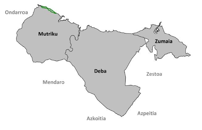
Natural Spaces
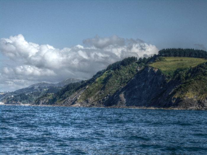
From the sharp cliffs bathed by the Cantabrian Sea to the high limestone peaks of the Izarraitz massif, the variety of landscapes in the Basque Coast Geopark is certainly generous. Intertidal zones, estuaries, holm oak groves, countryside and Atlantic forests follow one another and make up a diverse mosaic of biodiversity that justifies the existence of four protected natural areas in a territory that barely exceeds 88 km2.
In the marshes, on the dunes and on the cliffs, the vegetation faces the powerful influence of the ocean and shows surprising adaptations to resist its onslaught. When the tide goes down, the underwater world discovers its secrets in a multitude of intertidal pools bursting with color.
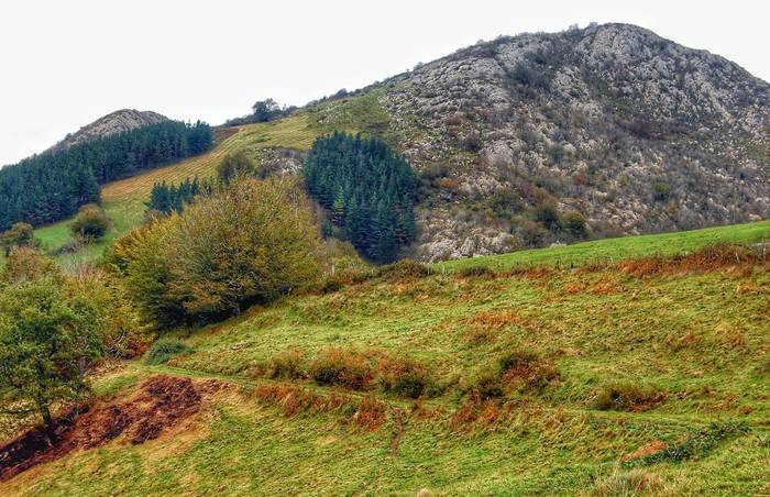
Inland, the tortuous reliefs of mountains and valleys accommodate large forested areas, dotted here and there by farms and green mountain pastures linked to the hard life of the farmhouse. In addition, the perforated limestone mountains of the interior offer refuge for an interesting cave fauna, in which some bat species whose survival is highly threatened stand out.
Outside of the protected natural areas, there are also places of great natural value, perhaps not as extensive, but of undeniable charm and interest.
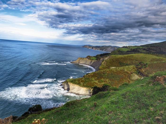
Protected Natural Landscape of the Deba-Zumaia coastal section
On the border between land and sea, the Protected Natural Landscape of the Deba-Zumaia coastline is a mosaic of habitats. Its 4,300 ha of surface are divided between the coastline, where the vegetation of the cliffs and moors and Atlantic grasslands stand out, and the marine environment, with large intertidal surfaces and underwater meadows of red algae.
The accesses to this natural space are the beaches of Itzurun and Algorri, in Zumaia, and, in Deba, the enclaves of Elorriaga, Errotaberri, Itxaspe, or Lapari beach. From these points, the marked trails such as PR-Gi 5001, SL-Gi 5001, SL-Gi 5002 and GR 121 make it easy to discover every corner of the Protected Natural Landscape. In Zumaia, in addition, the Algorri Interpretation Center offers extensive information about it.
Its declaration as a protected natural area dates from 2009. The cliffs and two open sea areas are Integral Reserve Zones.
_display.jpg)
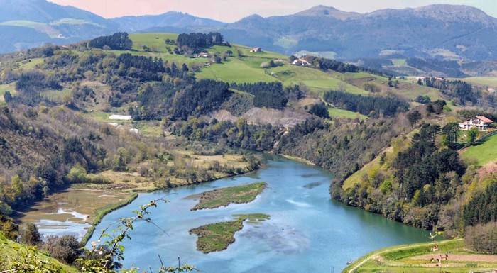
Special Conservation Area of the Urola estuary
Where sea waters collide and mix with sea waters, the Urola estuary shows the typical ecosystems of the Cantabrian estuaries, which certify its inclusion in the Natura 2000 Network. Among its habitats, we must highlight the Atlantic marshes, riverside forests, Cantabrian holm oaks and coastal dunes.
Although a small part of this space belongs to Zestoa, most of its 112 ha are in Zumaia. And it is also there where its main accesses are: Santiago beach and the Oikia neighborhood. In Zumaia there is also the Algorri Interpretation Center, where the peculiarities of coastal ecosystems are explained.
_display.jpg)
Special Conservation Area of Arno
The intricate Cantabrian holm oak forest of Mount Arno is the largest forest in the Geopark. Next to it, in the flatter areas, the Atlantic mowing meadows add biological and environmental variety to this space that was named SCA (ZEC) of the Natural Network 2000 in 2012.
A large part of the natural area -with a surface area of 1,122 hectares- is very difficult to access, which is why it is advisable to approach it from the Olatz neighborhood and the Kalbario hill; and following the Olatz georoute signposted as PR-Gi 47.
_display.jpg)
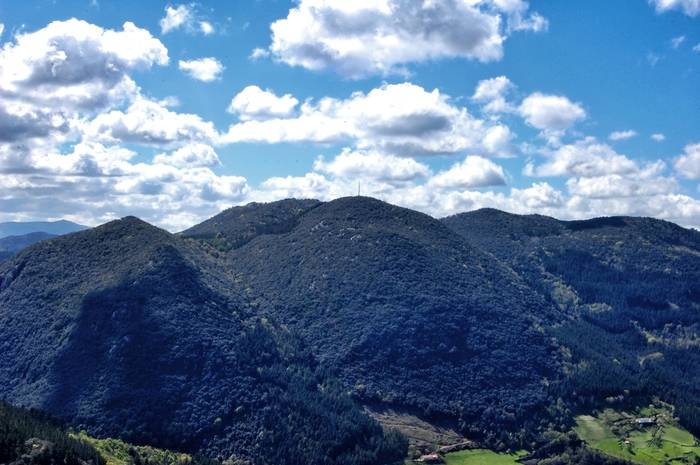
Special Conservation Area of Izarraitz
The rocky peaks of Izarraitz are the highest point of the Geopark and its karst character is manifested in a landscape dotted with sinkholes, lapiaces and caves. Among its numerous habitats, beech forests, mountain pastures and mixed forests on the foot of limestone cliffs stand out. It is also an area of great importance for the conservation of various species of bats.
This area, protected by the Natura 2000 Network since its inclusion as SCA (ZEC) in 2012, has an area of 1,593 ha and is shared by the municipalities of Deba, Azkoitia, Azpeitia and Zestoa. To get to know it, it is convenient to visit the Lastur neighborhood and the Mugarrigain hill, both in Deba, and the Goltzibar valley, shared by Deba and Zestoa. In Lastur there is a small karstic landscape interpretation center.
_display.jpg)
Other natural spaces
Deba river estuary
Despite having undergone a profound transformation due to human action, the Deba estuary still maintains Atlantic marshes of some value. For this reason it has been protected since 2004. In addition, conservation work has been carried out in the areas known as Casacampo and Artzabal, as well as a timid restoration of the dunes of the Santiago beach.
Its 92 ha surface area is accessible from Casacampo and Artzabal, on both banks of the estuary.
_display.jpg)
Mount Andutz
With access from Itziar, Mount Andutz is over 600 m high and has its geological origin in the Lower Cretaceous, when the great coral reef from which its rocks come grew under the sea.
Of 213 ha, its karstic nature emerges at every step in lapiaces, sinkholes, sinks or caves, and is also reflected in the Cantabrian holm oak groves, the Atlantic moors and the montane pastures that grow on its slopes.
_display.jpg)
Mutriku-Saturraran cliffs
In this narrow coastal strip of 23 ha, the most striking thing is the dark color of its rocks, a consequence of the accumulation of organic matter during its formation. They are the oldest geological materials in the Geopark and come from the end of the Lower Cretaceous.
From any of its accesses, through the Burumendi and Saturraran beaches, or the Galdona neighbourhood, the landscape shows Atlantic grasslands, Atlantic moors and vegetation on coastal cliffs.